Image

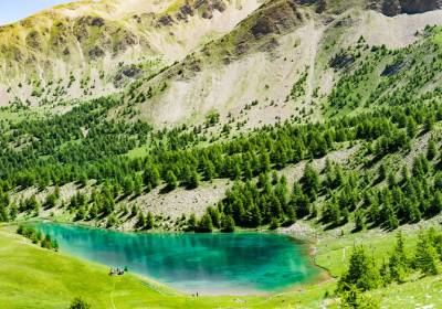
Starting from Lake Sainte-Marguerite (remember to add the time, distance, and elevation gain to the lake), follow the ridges of Les Orres to the summit of Aupillon, where you will enjoy a stunning panoramic view.
➡️ START:
You will first need to reach Lake Sainte-Marguerite via one of the suggested routes (and therefore add up the time, elevation gain, and distance).
➡️ ROUTE:
Once at the lake, take the ascent to the left. The trail is sparsely marked but easy to follow. It climbs in switchbacks for 2 km through very rocky terrain.
Upon reaching Col de l’Aupillon, turn left to reach the summit.
There are two options for the descent: either return via the same route or continue along the ridge westward. This will lead you to Col de l’Âne, from where a trail descends back to the lake.


Free access.

The must-do hike in Les Orres! Lake Sainte Marguerite is an ideal spot for a cool picnic. In the heart of beautiful alpine pastures still grazed by cows, you can hear and see...
La randonnée incontournable des Orres ! Départ depuis le sommet du télésiège Pousterle, en passant par le Belvédère (n°4). Balade longue et aérienne.
Un havre de paix au...