Image


Starting from the lake (remember to add the time, distance, and elevation gain to the lake), hike through a beautiful valley to reach a panoramic view at Col de l’Âne, Côte Ronde, or for the more experienced, the Pic du Silhouraïs.
➡️ START:
You will first need to reach Lake Sainte-Marguerite via one of the suggested routes (and therefore add up the time, elevation gain, and distance).
➡️ ROUTE:
- To Col de l’Âne: 3.4 km / 1h45 / +290 m
The most accessible of the three options. From the lake, take the path to the right through the pastures. The trail skirts a rocky ledge and ascends into the valley.
Upon reaching the scree slope, a series of switchbacks leads to the pass. At the top: a stunning panorama of the Ubaye Valley.
Return via the same route.
- Côte Ronde: 5.4 km / 3h30 / +500 m
From Col de l’Âne, follow the ridge to the right. It gradually narrows until reaching the summit of Côte Ronde (Costa Rouenda), marked by a large cairn.
- Pic Silhouraïs: 7.4 km / 4h30 / +610 m
From Côte Ronde, continue along the ridge to reach Pic Silhouraïs.
⚠️ Strongly discouraged for hikers with a fear of heights.
Free access.
Traversée de pâturages, respectez le travail des éleveurs et la tranquillité des animaux.
LES CAIRNS, PHARE DU RANDONNEUR
Les cairns sont des amas de pierre disposés en montagne afin d'aiguiller les randonneurs : ils balisent les sentiers peu visibles.
Mais attention à ne pas les suivre aveuglément ! À d'autres endroits, les cairns peuvent servir à repérer un point particulier comme un sommet, un col ou une grotte.
⚠️Il faut faire très attention à ne pas construire des cairns hors du sentier, au risque de perdre un randonneur pris dans le brouillard ou ayant perdu sa trace.
De plus, ne déchaussez pas de pierres : tout cela accélère l'érosion des sols et perturbe les êtres vivants ayant trouvé refuge dans le cairn.

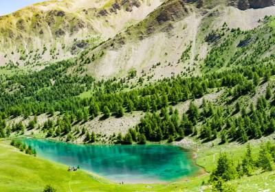
The must-do hike in Les Orres! Lake Sainte Marguerite is an ideal spot for a cool picnic. In the heart of beautiful alpine pastures still grazed by cows, you can hear and see...
La randonnée incontournable des Orres ! Départ depuis le sommet du télésiège Pousterle, en passant par le Belvédère (n°4). Balade longue et aérienne.
Un havre de paix au...